

TOPO Climbing | CLIMBING7.COM
Publié le

On the border between Aude and Ariège, in the heart of the Pays de Sault, the Pic de Sarrasis cliffs offer an ideal climbing spot to enjoy sunny winter days. With excellent rock, impeccable equipment and fairly long routes between 20 and 30m, you can enjoy climbing from 5c to 6c. The Scaramus sector has evolved with new routes, and the following sectors are waiting to be discovered. Here's a first glimpse of this quiet spot, far from the noise and surrounded by nature.
❱❱ Technical summary
► Itinerary : Rind climbing site.
► Geographical situation : The cliff is located between the villages of Belcaire and Roquefeuille, in the Aude department (11), near the Col du Chioula.
► Technical difficulties : Routes from 5a to 7a+ (Scaramus sector)
► Orientation : The cliffs face due south, sheltered from the wind and ideal for a sunny day in winter.
► Field and environnement : Very adherent, compact limestone rock. The lower part of the paths is generally shaded, under shrubs.
► Gear and equipments : All routes are equipped with pads and linked belays. FFME-approved climbing site.
► General review : A great spot for winter climbing, in the sunshine, in a peaceful and accessible location.
❱❱ Access to the place
On the D613 road between Quillian (Aude) and Ax-les-Thermes (Ariege), take the small road between Belcaire and Roquefeuille, which passes at the foot of the Pic des Sarrasis cliffs. There is a parking area at the start of the access road. There's also an information panel on the climbing site.
❱❱ Map & topo
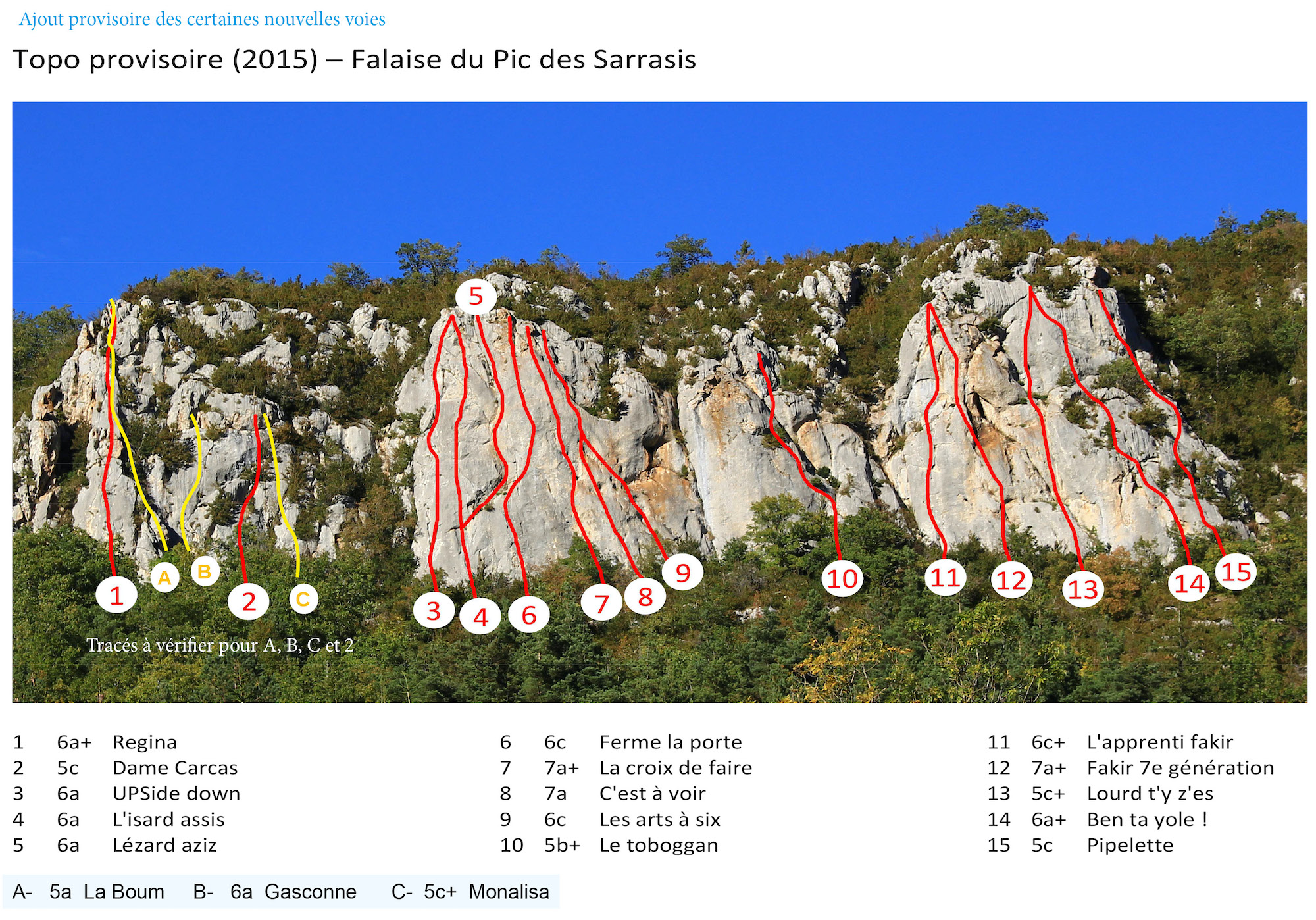
The topo is the one available on the Pyrénées audoises climbing website. It has been completed with the new routes we have tested, but there is still some uncertainty as to the exact location of the routes. It will be updated as soon as possible.
Voir en plein écran
❱❱ Itinéraire
From the parking lot below the cliffs, climb through the forest on the wide yellow path. Further on, we leave this trail to take a small path that climbs steeper into the undergrowth and reaches the base of the cliffs, at the Scaramus sector, below the Regina.
All routes are marked with a small green label with name and level. Some are detached or missing. The routes described below are those we climbed on the Scaramus sector from left to right. The heights given here are indicative. Number of points to be confirmed.
Pyrénées Audoises climbing site page with 2015 guidebook
Leave a Reply