

TOPO Climbing | CLIMBING7.COM
Publié le

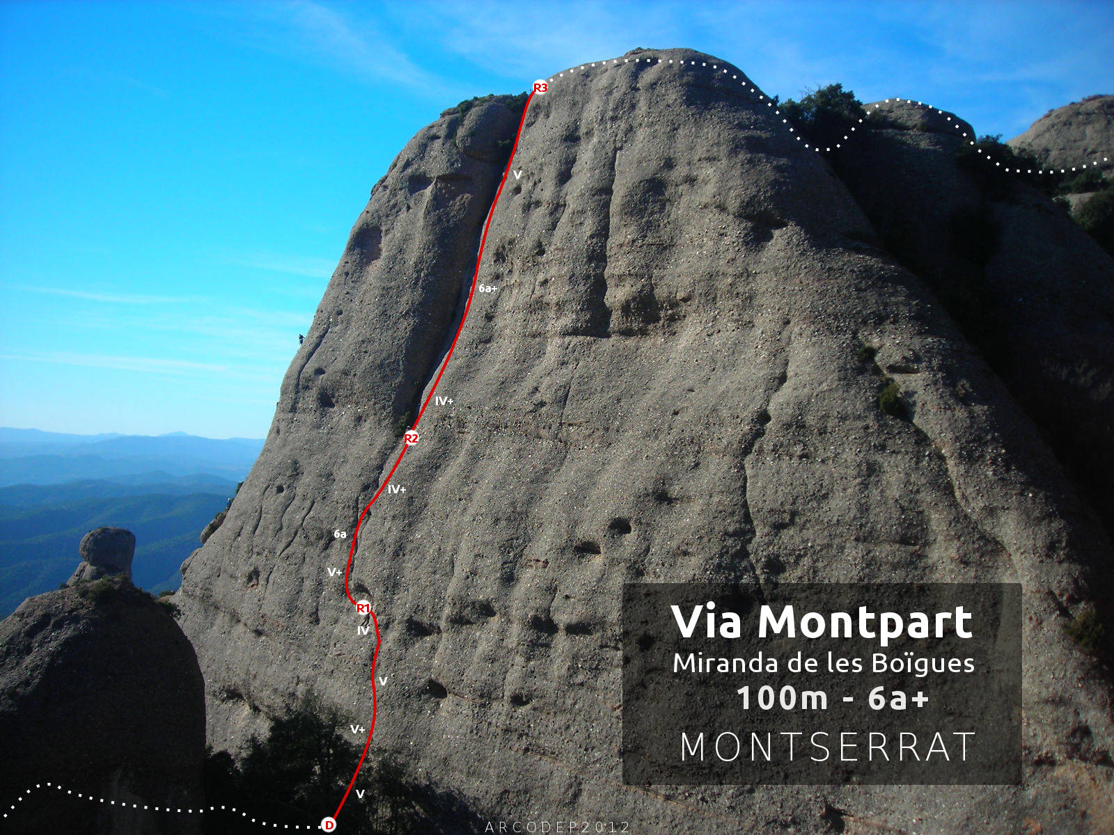
A great classic from Les Agulles, this magnificent route follows a logical and natural path, and was re-equipped in the 2000s so that it can be climbed free. On its eastern face, Miranda de las Boïgues forms a huge, almost vertical wall whose surface is shaped by a series of bumps and hollows. The long central crack in the upper part (L3) forms a dihedral that we climb up to the top of the rock. Advertised in the topos as V+/A0, V/A1e or 6a, the level of this free route seems more like 6a+ to us on the 3rd pitch, which is difficult, technical and very sustained (one or 2 pitches that could undoubtedly be worth 6b). What's more, the setting is simply incredible, in the heart of the Agulles, the climbing aerial and the equipment totally satisfactory. It's one of the most beautiful routes in the area.
❱❱ Technical summary
❱❱ Access to the place
From Barcelona. Take the A2 towards Leida and exit after Le Bruc, at the large Le Bruc hotel. Just after the freeway exit, fork right (abandoned petrol station) to climb a small winding road to the Col de can Maçana, where there is a parking area.
❱❱ Map & topo

❱❱ Itinéraire
Take the G.R 172 towards Santa Cecilia via the cami de la Roca Foradada. Turn right further on at the Collet de Guirlo (10′) to take the path leading to Coll de la Portella and Refuge Vicenç Barbé, marked in yellow and white. Pass La Portella and continue downhill to reach the refuge. Just before the last climb, you come across a small canal (de Cirerer) and a few metres before this canal, there's a tiny path that climbs to the left (cairn). This path is very lightly marked, so climb it by improvising a little. You come close to the base of the Miranda de les Boïgues, then skirt the base on the east side under the vegetation. Climb back up to the small pass (dead-end route) to find the obvious start of the route.
The east-facing route is 100m long in 3 pitches (30m, 25m, 45m) and was opened in 1960 (hence the "old-fashioned" grading). Equipment is varied (parabolas, burils, pitons) but sufficient for safe climbing. Bring fifteen quickdraws and a lanyard (sabine L3).
L1 (30m, V+)
Aim for the 1st nail at a fairly high point, then go straight on. There's soon a fairly fine V+ passage with few holds. Pass to the left of 2 nice hollows then follow upwards to finally find a 1st belay (old?) where you can belay. Finish by crossing to the left to reach the R1 belay in another hollow.
L2 (25m, 6a)
A magnificent, well-equipped pitch, even if the 1st point seems a long way off... Exit to the left through a small canal. There's a small overhang at the start, then we climb a small dihedral. It's superb, with straightforward holds and nearby pads. The exit from the canal is finer and almost overhanging (6a) and the 2nd part is less difficult to reach the R2 belay in IV+, located at the foot of the huge dihedral of L3 and to the right of the small shrubs.
L3 (45m, 6a+)
Great but difficult and sustained, this 3rd pitch is well worth the detour. The first few meters are easy, IV+/V, but you soon come to an arduous, fine passage. We can't use the dihedral on the first steps because the rock is smooth and there are no holds in the crack. You have to pass over the plate and it's really very thin, not very comfortable and you leave a lot of juice (with some awkward left-hand carabiners). On the other hand, at the top you can get close to the dihedral and use holds on small stones that come out, then put your hands in holes to finally get out with Popeye's arms (6a+ minimum in free climbing, you can switch to A0 or A1e). The final third is easier (V), but the points are much further apart. Secure yourself on the tree before finishing at the R3 belay just below the summit.
Descend to the west, de-escalating (a little tense), then climb a 2nd summit to de-escalate again and finally reach the Agulles traverse path. Descend to the left to reach La Portella, then the approach path in the opposite direction to the parking lot.
Leave a Reply