


TOPO Climbing | CLIMBING7.COM
Publié le
 Partager sur WhatsApp
 Partager sur Twitter
Partager sur Instagram
Partager sur Twitter
Partager sur Instagram

 Partager sur Facebook
 Imprimer le topo
 Laisser un commentaire

Another very accessible route on this aiguille de l'Arbret, in the heart of the Agulles sector, on the west side of Montserrat. Ideal for beginners. After Aresta Brucs, here's a pleasant, well-equipped route for beginners to discover the cirque des Agulles and even the vertiginous north face with its plunging view from the summit. A great outing, easy enough to make you want to continue exploring the other routes on the rock: Om Mani Padme Hum, la realidad paralela, both also very accessible, and on the west face, the more demanding via Vicenç Soto (210m) (6a+).
❱❱ Technical summary
❱❱ Access to the place
Go to Coll de Can Maçana, at the westernmost point of the Montserrat massif. From Barcelona, take the A2 and exit at the Brucs hotel, after the Bruc exit. Immediately afterwards, turn off towards Montserrat and the monastery, and after a few hairpin bends, reach the Can Maçana pass. Park in the parking lot on the right just before the pass.
❱❱ Map & topo
❱❱ Itinéraire
Take the G.R 172 towards Santa Cecilia via the cami de la Roca Foradada. Further on, fork right (10-minute walk) to take the path leading to Coll de la Portella and Refuge Vicenç Barbé, marked in yellow and white. Once past La Portella, take the path furthest to the left (marked in red), which runs along the ridges. Allow 3/4 hour's walk to reach the foot of l'Arbret. This is the needle you'll find on the left of the path, about 10 minutes after descending a gorge equipped with a white knotted strap. The via Aitor starts on the south side, before the path climbs to a small pass. A sign indicating the route is fixed to the rock.
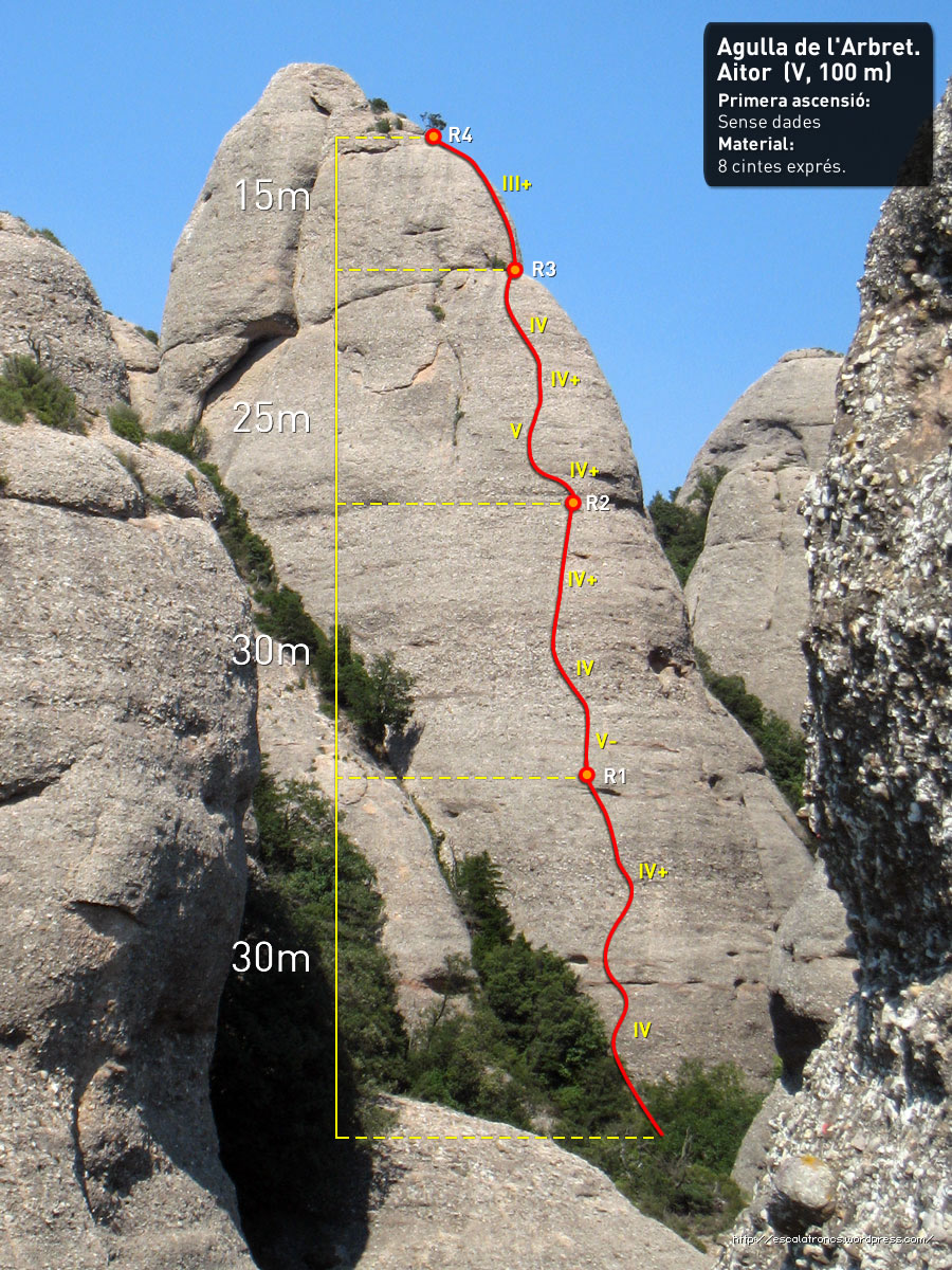
The route faces due south and is 100m long in 4 equipped pitches (30m, 30m, 25m, 15m). Bring 12 quickdraws and a few lanyards for Sabines and belays. Maximum free climbing level is V.
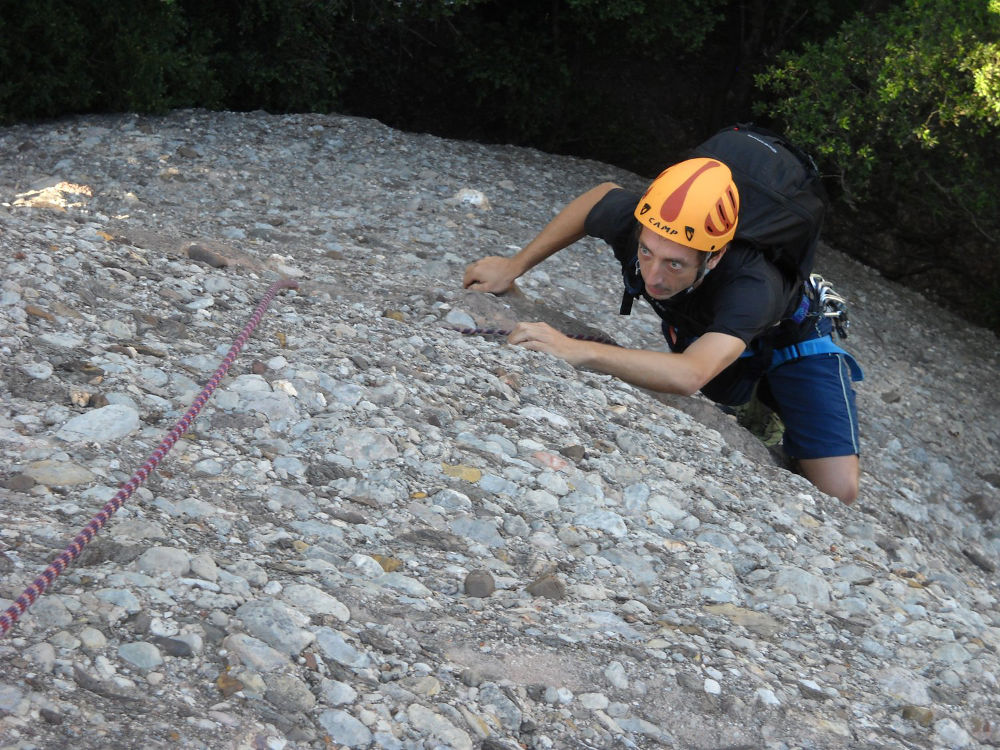
L1 (30m, IV+/V)
Easy, well-equipped pitch. Start slightly diagonally to the left, then climb straight up past the first hump. A more vertical passage at the end of the pitch and a comfortable belay 1.
L2 (30m, V)
The start is fairly vertical, diagonal to the left and then straight up. Good holds and a pleasant length with an increasingly aerial view of the sector. Comfortable R2 belay too.
L3 (25m, V)
After a left-hand start on an incline, a finer central passage, small holds to finish on easy IV. The end of the pitch is in the shrubbery and the R3 belay can be climbed either on the trunks or on the nails now fixed next to them.
L4 (15m, III)
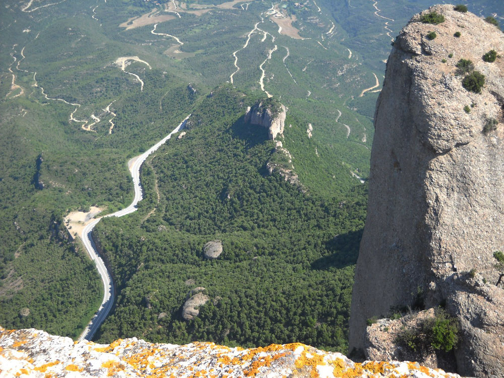
This section is shared with the Aresta Brucs. Skirt the groves to the right, ending up on the near-summit at a small isolated tree (R4). The true summit can be reached by finishing free (III) and admiring the 250m plunging cliffs on the north side: impressive!
A very airy 55m abseil on the east face, in a fault before the summit. It can also be done with 2 abseils of 20 + 35m to get back to the Agulles path before retracing your steps to the parking lot.


Leave a Reply