

TOPO Hiking | CLIMBING7.COM
Publié le
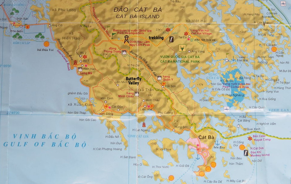
Cat Ba island, southwest of Hanoi, at the gateway to Lan Ha and Halong Bay, North Vietnam. At the heart of the island, a single trekking trail leads through the jungle from the center to the village of Viet Haï. After being dropped off by scooter at the national park gate, on the road linking Cat Ba to Gian Lam, an old disused road plunges eastwards into the impenetrable forest, threading its way through the karst peaks that cover almost the entire surface of this piece of land at the entrance to the Gulf of Tonkin. Then the road ends. A vaguely-marked but easy-to-follow trail leads deep into the rainforest, over one or two passes and down the other side to Viet Hai. Suffice to say, it's impossible to go 2m off the trail, so dense is the vegetation. There's virtually no view, you're right there with no landmarks. A few easy climbs. Giant plants, oversized trees, intertwined lianas, strange noises, crawling creatures straight out of a Leo abum. It's best to avoid stopping for too long, as we're not necessarily welcome here. Old, rusty and decrepit signs tell us from time to time that we're still on the right path, but no more. It takes a good 3 hours to get out of the forest and into the village, and at least another hour to reach the tiny port of Viet Haï. The return trip on a walnut shell is also well worth the detour. An hour of leisurely gliding over the green waters of Tonkin, weaving in and out of the blocks of go-karts planted everywhere, and rounding off the day by Lan Ha Bay to the port of Cat Ba, our point of departure.
❱❱ Technical summary
❱❱ Access to the place
From the town of Cat Ba in the south of the island. The easiest and cheapest way is to grab a "motorcycle" and get dropped off at the park entrance on the Giam Lam road ($4) in about 15′. There, pay the park entrance fee at the ticket office for around $2. The trek starts a little further on, on an old road that curves off at right angles after the park entrance.
❱❱ Map & topo

❱❱ Itinéraire
The trek can be divided into 3 parts. You'll need long pants and, above all, good footwear, as there's no possibility of refuelling en route. For the return trip by "basket boat", it's best to negotiate with Asia Outdoors, located upstairs in the Good Bar on the port, beforehand (just under $20 for the group).
Part 1 (45′)
From the start on the disused road. We head gently into the jungle. The track is wide and the gradient not very steep. Beautiful plants along the way. A left fork indicating "Pond" leads nowhere. Continue straight on to the end of the road. Easy undulating trail.
Part 2 (2h30)
This is the heart of the trek. About 8 km to Viet Haï. An easy-to-follow trail goes deep into the jungle this time. A small discovery trail forms a loop on the left. Strange noises, a little movement on the ground, up in the trees, don't venture off the trail. Then pick up the trail again. We'll pass the pass at the foot of Mai Bau pic. There's a lot more ascent, several small passes, it's quite physical. We pass right between the plants and trees, which tend to take up the slack, and on the ground we come across some surprising encounters: snakes, space frogs, phase like the forearm, black snails, combat centipedes... Much further on, you pass a pond, the "Frog Pond", with no frogs but crabs. The end of the trail descends steeply towards Viet Haï.
Part 3 (1h15)
From the village of Viet Haï to the port. Wide road, more open landscape and arrival at the lagoons, which form long, narrow meanders among the rocks.
By sea. If you booked through Asia Outdoors, a wooden hull awaits you. A 1-hour cruise across Lan ha Bay to Cat Ba harbor at sunset.

Leave a Reply