

TOPO Climbing | CLIMBING7.COM
Publié le

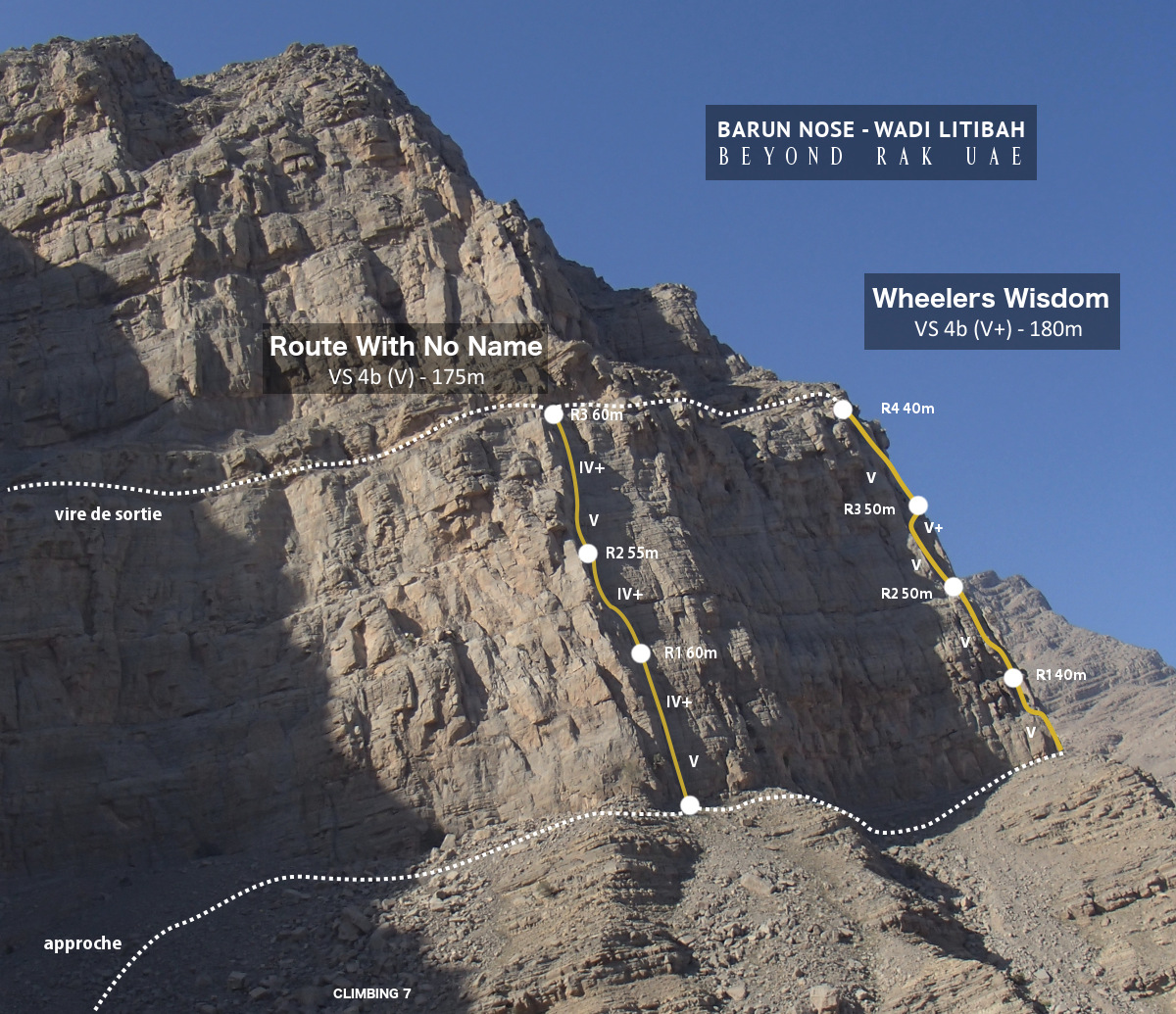
End of season in the Emirates before summer in Europe. One last climb to keep in shape and discover a new climbing sector at the entrance to Wadi Litibah, which joins Wadi Ghalilah at this point. This great trad route with no name (that's what it's called!), listed in Alan Stark's topo (2005), climbs the Barun Nose, a huge pillar at an angle to the impressive Barun Wall on the right and the Dreamland and Shady Circus cirques on the left. This is a beautiful 200m route in very accessible V rock of very good quality, which can be climbed in 3 or 4 pitches, still a little shaded in the morning. Fortunately, the 41° temperatures make the effort more difficult. The long traverse back on a very airy ledge is also worth the detour, with a few hyper-exposed passages for a classic return after the Shady Circus.
❱❱ Technical summary
❱❱ Access to the place
Follow the road north out of RAK towards the Oman border. After the large cement works, turn right towards Wadi Ghalilah (signposted). Drive up Ghalilah, past the small villages and turn right to reach the dam painted in UAE colors. Just after the dam, take the track in the torrent bed and park quickly, as the Barun Nos is on the right, easily recognizable, some 200m from the track.
❱❱ Map & topo

❱❱ Itinéraire
This involves crossing the wadi towards the walls and climbing up the stony slope to reach the foot of the cliffs. Here you have to pass the corner of the Barun Nose with its characteristic tree clinging to the rock, and the start is just behind, at the foot of the long dihedral of the route.
The route, opened in 1999, faces south-east and is 175m long. Specified as a 4-pitch route, it can be done in 3 (60m, 55m, 60m) by going to the end of the ropes. There's no equipment in place, apart from a strap left on 2 stoppers at the height of what may be belay 1 (45m from the ground). Provide a full set of friends, doubling from 0.75 to 3, and a full set of hangers. Very good rock, maximum level in V, well supported in places. The route is rated VS, 4b English grade. Alan Stark's topo is available here (extract on Beyond RAK sectors).
L1 (60m, V)
It starts with a vertical section in a narrow dihedral, the most difficult part of the route. After about 30m, we exit onto a steeper section (IV+). Climb back up, pass the strap and place the belay higher up.
L2 (55m, IV+)
Easier length. Climb a little further up the crack and angle left to reach the foot of a large, long rock hanging on the wall, forming a wide crack with the slab on the right. Place the R2 belay at the bottom of the crack.
L3 (60m, V)
The first 20 m are more vertical (V), but the rock is very good, even if it doesn't look like it. After the small wall, it's easier. continue along the cracks, a little to the right, and finish straight up to the exit ledge. The rock is a little less hard at the end, and the belay can be done from the ledge.
It's a long, exposed route. It's a matter of following the ridge that crosses all the cliffs on several cirques until you pass Shady Circus and beyond to find the gully that allows you to descend. Some passages are barely 50cms wide with 200m of gas next to them, but most can be avoided by climbing a little. Unclimb the final gully and finish down the left-hand slope with the car in your sights.

Leave a Reply