

TOPO Via ferrata | CLIMBING7.COM
Publié le

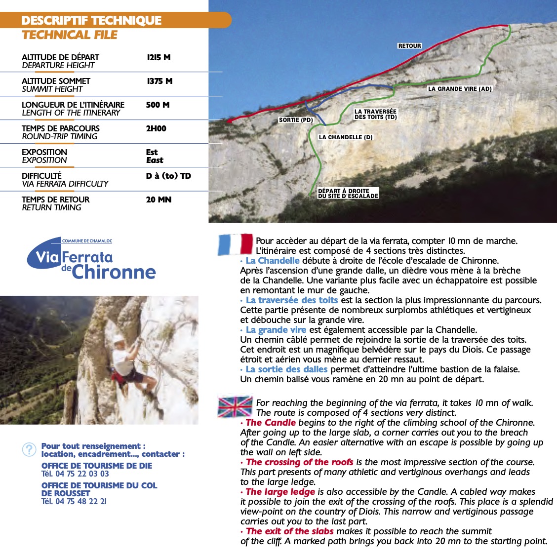
At the southern entrance to the Vercors, in a magnificent high-mountain landscape, the via ferrata de Chironne offers a very interesting, aerial, sporting route, with an original passage behind a rocky needle and a central section with a sustained, physical overhang. Very popular in high season, the route is well worth the detour for the exceptional panoramic views it affords over the Drôme valley. Options are available to enjoy the route with less difficulty, but the route remains hard and is aimed at experienced climbers.
❱❱ Technical summary
The data correspond to the 2 linked parts.
■ S tarting point: Col de Rousset, Chamaloc, Drome (26)
■ Type of route: via ferrata
■ Direction: east
■ Length: 500 m
■ Vertical rise: +160 m
■ Estimated total time: 1h30 to 2h30
■ Min and max altitude: 1215 m / 1375 m
■ Equipment in place: excellent, bars, beams, monkey bridges and long zip lines
■ Equipment required: standard equipment
Difficulty: D/TD or K3/K4, the most difficult section is avoidable.
❱❱ Access to the place
From Die, head north on the D518 towards Chamaloc. Continue past the village and climb the series of steep switchbacks to reach the Col de Rousset. Park just before the tunnel on the right, or a little earlier on the side if the parking lot is full.
❱❱ Map & topo

❱❱ Itinéraire
From the parking lot, walk along the road back downhill to quickly find the via information sign and the track that climbs to the base of the cliffs, following a section of the GR 93. It climbs gently upwards and once below the cliffs, leave the GR and take the tiny bit of path that leads to the start, at the foot of a high pillar.
Perfectly equipped, almost too much so in places, with chained belays to call back just in case. Marking and signposting during the route and on the way back are impeccable.
From the summit, descend following the huge cairns and skirting the wall. At the bottom, turn left down the slope and, after a large hairpin bend, you'll find a wide path for the GR 93 Pays du tour du Vercors dromois. You're soon back at the starting parking lot at Col de Rousset.
Topo de la ferrata et de toutes les via ferrata de la Drome published by the Communauté des communes du Diois(PDF)

Leave a Reply